History for the Relaxed Historian
HISTORY FOR THE RELAXED HISTORIAN

PEOPLE IN HISTORY          WARS, BATTLES AND REVOLUTIONS          MAP ARCHIVE          FAMOUS SPEECHES


GOVERNMENTS IN HISTORY          HISTORIC DOCUMENTS          HISTORIC PLACES AND LOCATIONS          ALL-TIME RECORDS IN HISTORY


SOURCE TEXT          SOURCE DOCUMENTS          HISTORY DICTIONARY          TIMELINES          ARCHAEOLOGICAL RECORDS


HOME   -   HISTORY MAPS   -   United States 1790-1900


Map Description
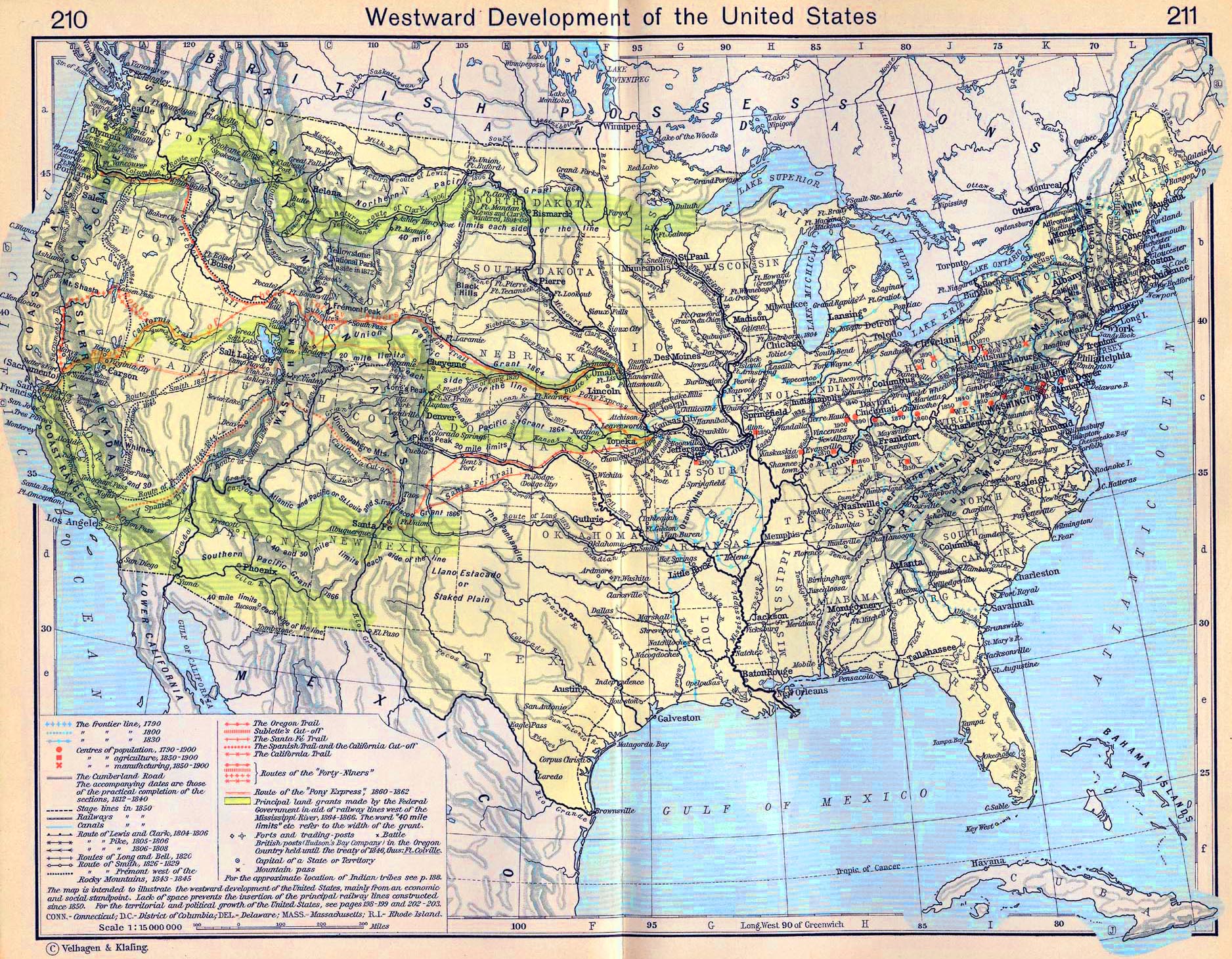
Historical Map of the Westward Development of the United States, 1790-1900.

The map is intended to illustrate the westward development of the United States, mainly
from an economic and social standpoint. Lack of space prevents the insertion of the principal
railway lines constructed since 1850. For the territorial and political growth of the United States,
see pages
198-199 and 202-203.

Illustrating

The frontier line 1790
The frontier line 1800
The frontier line 1830

Centres of population 1790-1900
Centres of agriculture 1830-1900
Centres of manufacturing 1850-1900

The Cumberland Road
The accompanying dates are those of the practical completion of the sections, 1812-1840

Stage lines in 1850
Railways in 1850
Canals in 1850

Route of Lewis and Clark, 1804-1806
Route of Pike, 1805-1806
Route of Pike, 1806-1808
Routes of Long and Bell, 1820
Route of Smith, 1826-1829
Route of Fremont west of the Rocky Mountains, 1843-1845

The Oregon Trail
Sublette's Cut-off
The Santa Fe Trail
The Spanish Trail and the California Cut-off
The California Trail
Routes of the "Forty-Niners"
Route of the "Pony Express" 1860-1862

Principal land grants made by the Federal Government in aid of railway lines west of the Mississippi River, 1864-1866.
The word "40 mile limits" etc. refer to the width of the grant.

Forts and trading posts
British posts (
Hudson's Bay Company) in the Oregon Country held until the treaty of 1846 are underlined
Battle
Capital of a State or Territory
Mountain pass

For the approximate
location of Indian tribes see p. 188


Credits
University of Texas at Austin. Historical Atlas by William Shepherd (1911).


Related Links
About Lewis     About Clark


Map of the Westward Development of the United States, 1790-1900


More History


People in History

Historic People - Main

People in History A - C

People in History D - F

People in History G - I

People in History J - M

People in History N - Q

People in History R - Z

Royal Families

Tribes & Peoples

Explorers, Scientists & Inventors

Musicians, Painters & Artists

Poets, Writers & Philosophers

First Ladies

Native Americans & The Wild West

Troublemakers

Historians

Archaeologists


Wars, Battles & Revolutions

Wars & Revolutions A

Wars & Revolutions B - E

Wars & Revolutions F - G

Wars & Revolutions H - J

Wars & Revolutions K - O

Wars & Revolutions P - R

Wars & Revolutions S - Z

Wars & Revolutions Chronological

Battles A - C

Battles D - L

Battles M - P

Battles Q - Z

Battles Ancient Times - 1499

Battles 1500 - 1799

Battles 1800 - Today


Miscellaneous


History Dictionary A - F

History Dictionary G - Z

Source Text - By Title

Source Text - By Author

Historic Documents A - Z

Historic Documents Chronological

History News

Research

Downloads


Bored?

Castles and Palaces


Kids & History

Browse

About Us

Write Me


Sitemaps

Sitemap 01   Sitemap 02   Sitemap 03    Sitemap 04   Sitemap 05   Sitemap 06  
Sitemap 07   Sitemap 08   Sitemap 09    Sitemap 10   Sitemap 11   Sitemap 12
Sitemap 13   Sitemap 14   Sitemap 15    Sitemap 16   Sitemap 17   Sitemap 18
Sitemap 19   Sitemap 20   Sitemap 21    Sitemap 22   Sitemap 23


Site Search


HISTORY IN A NUTSHELL


© 2016 Emerson Kent