|

The Rio Grande River
BLM
Rio Grande
Bad news right off the bat:
The Rio Grande, the second longest river in
the United States,
is no longer a naturally flowing river.
 Source: NPS / Big Bend
/ The Flow of the Rio Grande

The Rio Grande River
NASA/Photograph Philip Greenspun
NASA's Earth Obervatory tells you:
Ever since the gun toting days of the Old
West, Texans and Mexicans have argued
bitterly over the rights to the water
flowing in the Rio Grande.
The river is one of the only sources of
fresh water in the dusty, sun-scorched,
region.
Access to this precious desert resource has
an impact on the health, wealth,
agriculture, and industry of communities on
both sides of the river’s banks.
Do rivers change their course by
nature?
Yes.
Did people monkey with the course of
the Rio Grande because it was a boundary?
Good question.
But even without human interference,
the natural changes alone caused enough trouble.
Case in point is the flood in 1864. Here's more from the Department
of Homeland Security, all in the spirit of Securing America's
Borders:
The Rio Grande changed course gradually with
each flood season, however the flood of 1864
resulted in the creation of large land
protrusions, called bancos, which
altered previously known borders.
One of those bancos came to be known
as Chamizal, which was named after the river
thicket plants that once covered the
territory.
Chamizal encompassed more than 600 acres
between El Paso, Texas, and Ciudad Juarez,
Chihuahua, Mexico, that would be held in
contention for almost a century.
More
 here.
here.

United
States / Mexico Border Region
International Boundary
and Water Commission
Among other issues, the changing
Rio Grande and resulting boundary disputes triggered the
foundation of above mentioned International Boundary and
Water Commission. These folks tell us:
The IBWC traces its roots to the 1848 Treaty
of Guadalupe Hidalgo and the Gadsden Treaty
of 1853, which established temporary joint
commissions to survey, map, and demarcate
with ground landmarks the new United States
(U.S.) – Mexico boundary.

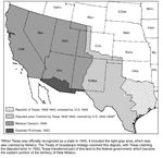
Treaty of Guadalupe Hidalgo
1848
and Gadsden Purchase 1853
The Guadalupe Hidalgo Treaty of February 2,
1848 established the international boundary
between the United States and Mexico.
The Treaty of December 30, 1853
reestablished the southern boundary of New
Mexico and Arizona to enable the United
States to construct a railroad to the west
coast along a southern route and to resolve
a question arising from the 1848 Treaty as
to the location of the southern boundary of
New Mexico.
The Convention of 1882 established another
temporary joint commission to resurvey the
western land boundary between the Rio Grande
and the Pacific Ocean, rebuild the old
monuments, and install additional monuments
where necessary. U.S. Commissioner John
Whitney Barlow and Mexican Commissioner
Jacobo Blanco resurveyed the borderline and
increased the number of boundary monuments
from 52 to 258. This survey started at the
El Paso, Texas – Ciudad Juárez, Chihuahua
border in 1891, and concluded at the San
Diego, California – Tijuana, Baja California
border in 1894. Later as border populations
increased during the 1900’s, the Commission
installed 18 additional boundary monuments
for a total of 276.
As the settlements grew along the boundary
rivers (Rio Grande and Colorado River),
settlers began developing adjoining lands
for agriculture. In the late Nineteenth
Century, questions arose as to the location
of the boundary and the jurisdiction of
lands when the boundary rivers changed their
course and transferred land from one side of
the river to the other. As a result, the two
Governments adopted certain rules to deal
with such questions in the Convention of
November 12, 1884.
More
 here.
here.
More History
|