|
Maps by Continent -
Asia Maps J-O
The Asia History Map Collection is
indexed first alphabetically, then chronologically.
|
 |
 Japan 1904
|
|
|
|
|
 |
Japan 1945 - World War
II: The Western Pacific. Japanese Homeland
Dispositions August 1945. Allied Plans for
the Invasion of Japan (Operation Downfall). |
|
|
|
|
 |
Japan 1945. The
Bombing of Japanese Cities. Extent of
Destruction by Bombing of Principal Cities. |
|
|
|
|
 |
Jerusalem,
Ancient |
|
|
|
|
 |
Jerusalem 1187
AD |
|
|
|
|
 |
Korea, Ancient |
|
|
|
|
 |
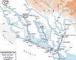
Korean War: Principal
Campaigns 1950 - 1953 |
|
|
|
|
 |
Korean War: June 1 -
September 1950 |
|
|
|
|
 |
Korean War: U.N.
Delay, Withdrawal and Defense, Operations
June 25 - August 5, 1950. |
|
|
|
|
 |
Korean War:
Taegu-Pusan Area, U.N. Defense, Situation
August 26, 1950, Operations Since August 5,
1950. |
|
|
|
|
 |
Korean War:
Taegu-Pusan Area, U.N. Defense, Situation
September 10, 1950, Operations Since August
27, 1950. |
|
|
|
|
 |
Korean War: South
Korea. U.N. Offensive, Situation September
26, 1950, Operations Since September 15,
1950. |
|
|
|
|
 |
Korean War: South
Korea. U.N. Offensive, Situation September
26, 1950, Operations Since September 15,
1950. Close-Up. |
|
|
|
|
 |
Korean War: North
Korea. U.N. Advance to the Yalu River,
Initial Chinese Counter-Attack, Situation
October 26, 1950, Operations Since October
7, 1950. |
|
|
|
|
 |
Korean War: North
Korea. U.N. Advance to the Yalu River,
Situation November 24, 1950, Operations
Since October 26, 1950. |
|
|
|
|
 |
Korean War: November
3, 1950 - January 1951 |
|
|
|
|
 |
Korean War: North
Korea. U.N. Chinese Communist Offensive,
Situation December 5, 1950, Operations
November 26 - December 15, 1950. |
|
|
|
|
 |
Korean War: January
1951 - July 1953 |
|
|
|
|
 |
Korean War: South
Korea. Second Invasion of South Korea,
Situation January 24, 1951, Operations Since
December 31, 1950. |
|
|
|
|
 |
Korean War: South
Korea. U.N. Counter-Offensive, Situation
April 22, 1951, Operations Since January 25,
1951. |
|
|
|
|
 |
Korean War: South
Korea. Operation Ripper, Situation March
6-31, 1951. |
|
|
|
|
 |
Korean War: Central
Korea. Communist Spring Offensive (First
Impulse), Situation on April 30, 1951,
Operations Since April 22, 1951, Probing
Attacks by U.N. Forces, May 1 - 10, 1951. |
|
|
|
|
 |
Korean War: Central
Korea. Communist Spring Offensive (Second
Impulse), Situation on May 20, 1951,
Operations Since May 14, 1951. |
|
|
|
|
 |
Korean War: Central
Korea. U.N. Offensive, Situation on November
27, 1951, Operations Since May 23, 1951. |
|
|
|
|
 |
Korean War: Central
Korea. Stalemate in Korea, General Defense
Line and Corps Sectors During the Period of
Armistice Talks, November 1951 - July 1953 |
|
|
|
|
 |
Kuwait - Map of the
Gulf War, Iraqi Invasion of Kuwait, 1990. |
|
|
|
|
 |
Luzon, Philippines, in
World War II: Communications Net, American
Dispositions, December 8, 1941. |
|
|
|
|
 |
Luzon, Philippines, in
World War II: Centrifugal Offensive,
December 10, 1941 - May 6, 1942. |
|
|
|
|
 |
Macedonian Empire 336 BC - 323 BC |
|
|
|
|
 |
Macedonian Empire 301
BC and 200 BC in Comparison |
|
|
|
|
 |
Macedonian Empire 301 BC |
|
|
|
|
 |
Macedonian Empire 200 BC |
|
|
|
|
 |
Malaya in World War
II: December 1941 - January 1942. |
|
|
|
|
 |
Maldive Islands 2009 |
|
|
|
|
 |
Maldives 2009 |
|
|
|
|
 |
Manila Bay 1898 |
|
|
|
|
 |
Manila - August 13,
1898, Capture of |
|
|
|
|
 |
Marco Polo
Travels 1271 - 1295 |
|
|
|
|
 |
Mediterranean Sea 550 BC |
|
|
|
|
 |
Mediterranean Lands after 1204 |
|
|
|
|
 |
Mediterranean Region
Political 1940 |
|
|
|
|
 |
Mediterranean,
Southeastern: Lebanon, Syria, Jordan,
Israel, Egypt, Saudi Arabia, Sinai Peninsula |
|
|
|
|
 |
Mediterranean,
Eastern: Turkey, Lebanon, Syria, Jordan,
Israel, Egypt, Saudi Arabia, Sinai
Peninsula, Libya. |
|
|
|
|
 |
Mediterranean and
Europe. Disposition of Marine Units,
Deployment of Army Task Force 201, 1958. |
|
|
|
|
 |
Megiddo - Sep 19-21,
1918, Battle of |
|
|
|
|
 |
Mesopotamia, Syria, and Egypt 1450 BC |
|
|
|
|
 |
Mesopotamia 1914 -
Anglo-Indian Invasion |
|
|
|
|
 |
Mesopotamia
January-July 1915 |
|
|
|
|
 |
Mesopotamia
July-November 1915 |
|
|
|
|
 |
Middle East and Europe
1943 |
|
|
|
|
 |
Middle East 2010 |
|
|
|
|
 |
Mongol Dominions
1300-1405 |
|
|
|
|
 |
Nepal 2011 |
|
|
|
|
 |
Okinawa April 1-8,
1945. |
|
|
|
|
 |
Okinawa April 9 - June
30, 1945. |
|
|
|
|
 |
Orient
and Mycenaean Greece 1450 B.C. |
|
|
|
|
 |
Oriental Empires 600 BC
|
|
|
|
|
 |
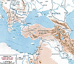
Ottoman
Conquest 1451 - 1566
|
|
|
|
|
 |
Ottoman
Empire 1481-1683
|
|
|
|
|
 |
Ottoman
Empire Dismemberment 1683-1908 |
|
|
|
|
 |
Ottoman
Empire Asia 1792
|
|
|
|
|
 |
Ottoman Empire 1914 |
|
|
|
More History
|
|