|
Maps by Continent -
Asia Maps P-Z
The Asia History Map Collection is
indexed first alphabetically, then chronologically.
|
 |
 Palestine, Ancient
 |
|
|
|
|
 |
Palestine
1250-1125 BC
|
|
|
|
|
 |
Palestine
1025-953 BC
|
|
|
|
|
 |
Palestine 953
- 722 BC
|
|
|
|
|
 |
Palestine 4 BC
|
|
|
|
|
 |
Palestine 1187
AD |
|
|
|
|
 |
Persepolis Palace
Layout 518 - 331 BC |
|
|
|
|
 |
Persian
Empire 500 BC |
|
|
|
|
 |
Persian Empire 490 BC |
|
|
|
|
 |
Persian Invasions
492-490 BC |
|
|
|
|
 |
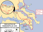
Persian Invasion
480-479 BC, Third |
|
|
|
|
 |
Philippine Islands:
Spanish American War 1898 |
|
|
|
|
 |
Philippines 1993 |
|
|
|
|
 |
Propontis, Ancient |
|
|
|
|
 |
Roman Civil War 49-45
BC |
|
|
|
|
 |
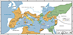
Roman Empire
4th Century |
|
|
|
|
 |
Roman Empire 5th
Century: Routes of the Barbarian Invaders |
|
|
|
|
 |
Rome's
Expansion 264 BC - 180 AD |
|
|
|
|
 |
Saudi Arabia 2011 |
|
|
|
|
 |
Scythia
4th century BC |
|
|
|
|
 |
Seats of
War 1740-1763 |
|
|
|
|

 |
Seats of
War 1788-1815 |
|
|
|
|
 |
Sinai Peninsula:
Israel's War of Independence, Operation AYIN,
December 22, 1948 - January 7, 1949. |
|
|
|
|
 |
Sinai Peninsula:
Israel's War of Independence, Campaign in
Sinai, Opening Phase, October 29-31, 1956. |
|
|
|
|
 |
Sinai Peninsula:
Israel's War of Independence, The Six Day
War, Israeli Advance, June 5-6, 1967. |
|
|
|
|
 |
Sinai Peninsula:
Israel's War of Independence, The Six Day
War, Conquest of Sinai, June 7-8, 1967. |
|
|
|
|
 |
Southeast Asia and
Eastern Frontier of India 1805-1907 |
|
|
|
|
 |
Southeast Asia in
World War II: Japanese Centrifugal
Offensive, December 1941. |
|
|
|
|
|
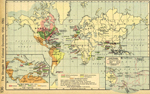
Spanish American War
1898 |
|
|
|
|
 |
Suez Canal Area.
Campaign in Sinai, Egyptian Crossing and
Attack, Israeli Counter-Attacks, October
1973. |
|
|
|
|
 |
Suez Canal Area.
Campaign in Sinai, Operation GAZELLE,
Egyptian Counter-Attacks, October 1973. |
|
|
|
|
 |
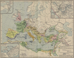
Syria, Mesopotamia, and Egypt 1450 BC |
|
|
|
|
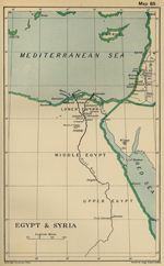 |
Syria and Egypt 1798 |
|
|
|
|
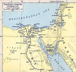 |
Syria and Egypt in 1798 |
|
|
|
|
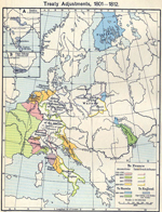 |
Treaties
1801-1812 |
|
|
|
|
 |
Troy and Vicinity |
|
|
|
|
 |
Turkey 2006 |
|
|
|
|
 |
Turkey 2010 |
|
|
|
|
 |
Tyre 333 - 332 BC |
|
|
|
|
 |
Tyre 333 - 332 BC |
|
|
|
|
 |
Tyre 333 - 332 BC,
Siege of |
|
|
|
|
 |
Vietnam War. South
Vietnam, Enemy Situation, Early 1964. |
|
|
|
|
 |
Vietnam War. South
Vietnam, NVA Plan for 1965. |
|
|
|
|
 |
Vietnam War. The Iron
Triangle, Operation CEDAR FALLS, January
4-24, 1967. |
|
|
|
|
 |
Vietnam War: the Tet
Offensive 1968 |
|
|
|
|
 |
Vietnam War. South
Vietnam, Attack into Cambodia, May - June
1970. |
|
|
|
|
 |
Vietnam War. South
Vietnam, Lam Son 719, February 1971. |
|
|
|
|
 |
Vietnam War. South
Vietnam, Spring Offensive 1972, Invasion
Across the DMZ. |
|
|
|
|
 |
Vietnam War. South
Vietnam, The Fall of MR II, The Fall of
Saigon, 1975. |
|
|
|
|
 |
World War II: Major
Operations in Asia and the Pacific 1939-1945 |
|
|
|
|
 |
World War II: The Far
East and the Pacific 1941. Major Japanese
War Objectives and Planned Opening Attacks. |
|
|
|
|
 |
World War II: The Far
East and the Pacific 1941. Major Allied
Forces and Positions, December 1941. |
|
|
|
|
 |
World War II: The Far
East and the Pacific. American Carrier
Operations December 7, 1941 - April 18,
1942. |
|
|
|
|
 |
World War II: The Far
East and the Pacific. Operations of the
Japanese First Air Fleet December 7, 1941 -
March 12, 1942. |
|
|
|
|
 |
World War II: Southern
Asia. Japanese Centrifugal Offensive January
- May 1942 |
|
|
|
|
 |
WWII: The Far East and
the Pacific. Allied Reorganization, March
30, 1942. Area Under Japanese Control,
August 6, 1942. |
|
|
|
|
 |
World War II: The Far
East and the Pacific. Status of Allied
Forces and Theater Boundaries, July 2, 1942. |
|
|
|
|
 |
World War II: Far East
and the Pacific. Original Allied Strategic
Concept, May 1943, and Situation in the
Pacific November 1, 1943. |
|
|
|
|
 |
World War II: The Far
East and the Pacific. Summary of Allied
Pacific Campaigns. Status of Japanese
Forces, February 1, 1945. |
|
|
|
|
 |
World War II:
Southeast Asia and the Pacific 1945. Final
Allied Offensives in the Southwest Pacific
Area, February 29 - July 1, 1945. |
|
|
|
|
 |
World War II: The Far
East and the Pacific. Areas Under Allied and
Japanese Control. Situation August 15, 1945. |
|
|
|
|
 |
Yellow Empire,
Karakorum 1300 |
|
|
|
|
|
|
More History
|
|