Map Description
History Map of WWII: Okinawa April 1945
Illustrating:
Operation ICEBERG
Operation Iceberg was the codename for the Allied invasion of Okinawa.
Ryukyu Islands (or Nansei Islands, 南西諸島) refers to a long chain of islands stretching southwest from Kyushu to Taiwan.
Okinawa Island is the largest and most populous island in the Ryukyu chain.
The primary Allied objective in capturing Okinawa was to secure a large, strategically located base close
to the Japanese home islands. Okinawa's proximity — about 350 miles from Kyushu — made it ideal as a staging area
for Operation Downfall, the planned invasion of mainland Japan.
The Battle of Okinawa was fought from 1 April 1945, when American forces landed on Okinawa, to 22 June 1945, when organized
Japanese resistance officially ended. However, clearance operations continued until 30 June.
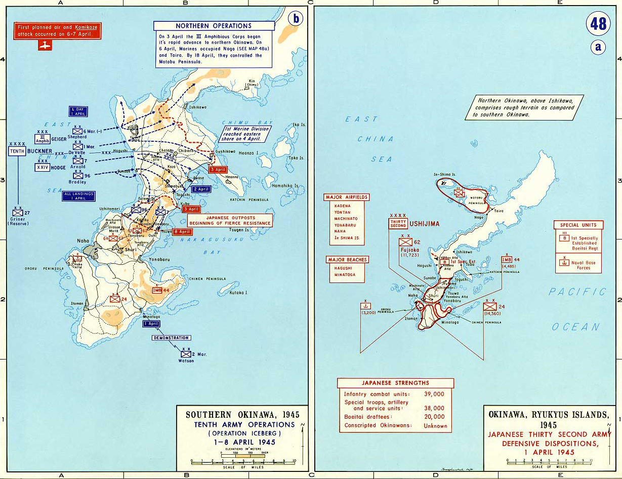
Map ⓐ
Okinawa: Japanese Thirty Second Army Defensive Dispositions
1 April 1945
The Japanese Thirty-Second Army, commanded by Lieutenant General Mitsuru Ushijima, was responsible for the
defense of Okinawa against the impending American invasion.
Their defensive dispositions on 1 April 1945, reflected a calculated strategy to maximize American casualties
and prolong resistance, buying time for the Japanese homeland to prepare for invasion, by exploiting Okinawa’s terrain,
fortifying the southern sector, and avoiding decisive engagement at the
beaches.
This approach set the stage for one of the bloodiest battles of the Pacific War.
The main defensive positions were concentrated in the southern third of Okinawa, particularly in the rugged terrain south
of the island’s narrow waist, utilizing natural caves, ridges, and reverse slopes for maximum defensive advantage.
The 32nd Army comprised approximately 77,000 troops, including regular army, naval personnel, and conscripted Okinawan laborers
and militia.
The core units included the 24th Division, 62nd Division, and 44th Independent Mixed Brigade, with additional naval infantry and support
elements.
The main defensive line, known as the Shuri Line, ran east-west across the southern part of the island, anchored on the Shuri Castle
area. This line was heavily fortified with interconnected bunkers, pillboxes, tunnels, and artillery positions.
Forward outposts and delaying positions were established north of the Shuri Line, but these were lightly held, designed to slow and
channel the American advance rather than stop it outright.
Japanese forces made extensive use of the island’s cave systems, creating deep, mutually supporting positions resistant to bombardment
and ground assault.
The defense relied on depth and elasticity: as American forces advanced, Japanese units would fall back to secondary and tertiary
positions, forcing the attackers into costly, close-quarters combat.
Guerrilla tactics, night infiltration, and local counterattacks were employed to disrupt American operations and sap morale.
Okinawan civilians were often mobilized for labor, support, and even combat roles, reflecting the total-war nature of the defense.
Map ⓑ
Southern Okinawa: Tenth Army Operations (Operation Iceberg)
1-8 April 1945
The Allied invasion of Okinawa was the largest amphibious assault in the Pacific Theater during World War II.
The operation began on 1 April 1945, with the landing of the U.S. Tenth Army on Okinawa’s western coast.
This map focuses on the first week of operations (1-8 April) in southern
Okinawa [go here for battle operations
9 April - 30 June 1945], during which the U.S. Tenth
Army achieved its initial objectives on Okinawa with minimal opposition, but these successes set the stage
for the brutal and costly fighting that would follow in the island’s southern defenses — a battle that would
have profound implications for the final phase of World War II in the Pacific, i.e. the extreme casualties and
resistance encountered convinced American leaders that a direct invasion of the Japanese home islands would
be even more costly, influencing the decision to use atomic bombs to force Japan’s surrender.
To be clear, while Okinawa’s high casualties (esp. U.S. ≈ 49,000 casualties including 12,500+ dead) reinforced
fears of even higher losses in an invasion of Japan, this was only one factor among many that led to the
use of atomic bombs. Others included Japanese refusal to surrender unconditionally, the ddesire to end the war
swiftly before Soviet involvement intensified, strategic demonstration of power (esp. to USSR), and war-weariness
as well as political pressure.
So, Okinawa contributed, but it wasn’t a decisive cause in itself.
Now, back to the first week on Okinawa:
The U.S. Tenth Army, commanded by Lieutenant General Simon Bolivar Buckner Jr., was a unique joint force comprised of both
Army and Marine Corps units, supported by extensive naval and air assets.
The initial objective was to secure beachheads, rapidly advance inland, and capture key airfields and terrain to support
further operations against Japanese defensive positions in the south.
On April 1, 1945 (Easter Sunday), American forces landed on the Hagushi beaches along the west-central coast of Okinawa.
The landings were largely unopposed, as Japanese defenders had concentrated their forces in the island’s southern region,
preparing for a protracted defense.
By April 8, U.S. forces had advanced swiftly across the narrow waist of the island, capturing Kadena and Yontan airfields
and cutting Okinawa in two. This maneuver isolated Japanese forces in the north from those in the heavily fortified south.
The Japanese, commanded by General Mitsuru Ushijima, deliberately avoided early engagement, instead relying on a
defense-in-depth strategy centered on the rugged terrain and fortified positions in the southern part of the island.
Their goal was to inflict maximum casualties and delay the American advance.
The rapid initial advance of the Tenth Army was deceptive; while early gains were substantial, the Americans soon encountered
fierce resistance as they approached the main Japanese defensive lines in southern Okinawa.
The campaign’s opening week demonstrated the effectiveness of Allied amphibious doctrine and joint operations,
but also foreshadowed the intense combat and high casualties that would characterize the subsequent battle for
the southern sector.
Operation Iceberg exemplified large-scale joint and combined arms operations, integrating land, sea, and air power on an
unprecedented scale in the Pacific.
The Japanese defensive approach on Okinawa, emphasizing attrition and fortified positions rather than immediate
counterattacks, marked a significant evolution in their Pacific strategy.
The first week’s operations highlighted the importance of operational surprise, rapid exploitation of initial gains,
and the logistical challenges of sustaining a large force in a hostile environment.
Credits
Courtesy of the United States Military Academy Department of History.
Related Links
About World War IIWWII Timelines
Click map to enlarge.
More History
