|
Map Description
History Map of WWII:
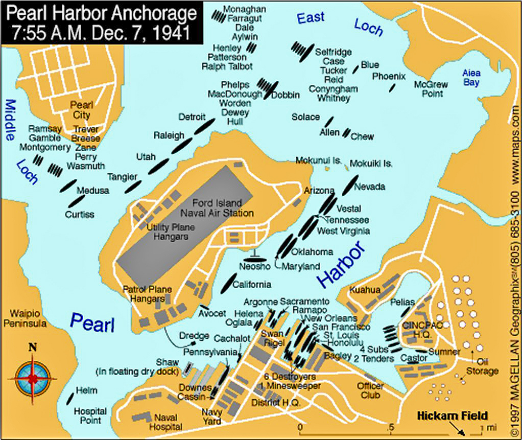
Pearl Harbor Anchorage, Oahu, Hawaii, 7:55 a.m., December 7, 1941
Illustrating
Middle Loch
East Loch
Aiea Bay
Pearl City
Waipio Peninsula
McGrewPoint
Utility Plane Hangare
Ford Island
Naval Air Station
Mokunui Island
Mokulki Island
Patrol Plane Hangars
Kuahua
Cincpac H.Q.
Oil Storage
Ramsay
Gamble
Montgomery
Trever
Breese
Zane
Perry
Wasmuth
Medusa
Curtiss
Tangler
Utah
Raleigh
Detroit
Phelps
MacDonough
Worden
Dewey
Hull
Henley
Patterson
Ralph Talbot
Monaghan
Farragut
Dale
Aylwin
Dobbin
Seltfridge
Case
Tucker
Reid
Conyngham
Whitney
Blue
Phoenix
Solace
Allen
Chew
Arizona
Nevada
Vestal
Tennessee
West Virginia
Oklahoma
Maryland
Neosho
California
Avocet
Dredge
Cachalot
Oglala
Helena
Argonne
Sacramento
Swan Rigel
Ramapo
New Orleans
San Francisco
St. Louis
Honolulu
Bagley
Pelias
4 Subs
2 Tenders
Castor
Sumner
6 Destroyers
1 Minesweeper
District H.Q.
Downes Cassin
Navy Yard
Naval Hospital
Hospital Point
Helm
Shaw (in floating dry dock)
Downes Cassin
Pennsylvania
Hickam Field
Credits
Magellan Geographix
Related Links
 About the Pearl Harbor Attack
 World War
II
 Franklin D.
Roosevelt
 WWII Timelines
 Isoroku Yamamoto
 Trinity Site Photos
 Pearl
Harbor Photos
 Map of the Pearl
Harbor Attack 1941

More History
 |