|
Map Description
Three historical maps of the
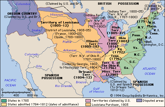
Expansion of the United States 1783-1854
I. 1783-1812
Green - States in 1783 (see
 Treaty of Paris 1783)
Yellow - States admitted 1784-1812 (dates of admittance)
Pink - Territories claimed by U.S.
Orange -
Louisiana Purchase 1803
Purple - Disputed areas (see also
West Florida)
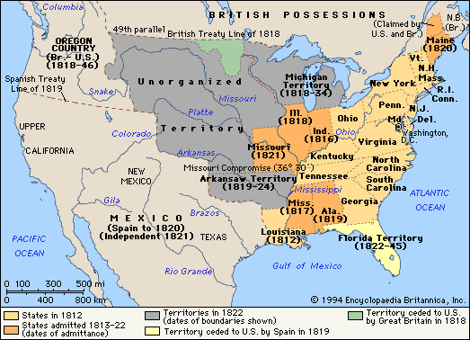
II.
1812-1822
Yellow - States in 1812
Orange - States admitted 1813-1822 (dates of admittance)
Grey - Territories in 1822 (dates of boundaries shown)
Light yellow - Territory ceded to U.S. by Spain in 1819 (see
Adams-Onis Treaty)
Green - Territory ceded to U.S. by Great Britain in 1818
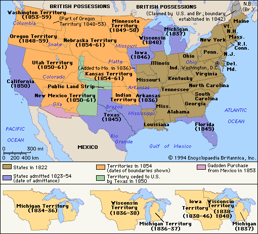
III.
1822-1854
Brown - States in 1822
Purple - States admitted 1823-1854 (date of
admittance)
Orange - Territories in 1854 (dates of boundaries
shown)
Green - Territory ceded to U.S. by Texas in 1850
Pink -
Gadsden Purchase
from Mexico in 1853
Michigan Territory (1834-1836)
Wisconsin Territory (1836-1838)
Michigan Territory (1836-1837)
Iowa Territory (1838-1846)
Wisconsin Territory (1838-1848)
Michigan (1837)
Credits
Encyclopædia Britannica Online.
Related Links
About the American
Revolution
About the Texas Revolution
About the Mexican-American War
About the Treaty
of Guadalupe Hidalgo
The United States 1783–1812
The United States 1812–1822
The United States 1822–1854
More History
 |
