|
Map Description
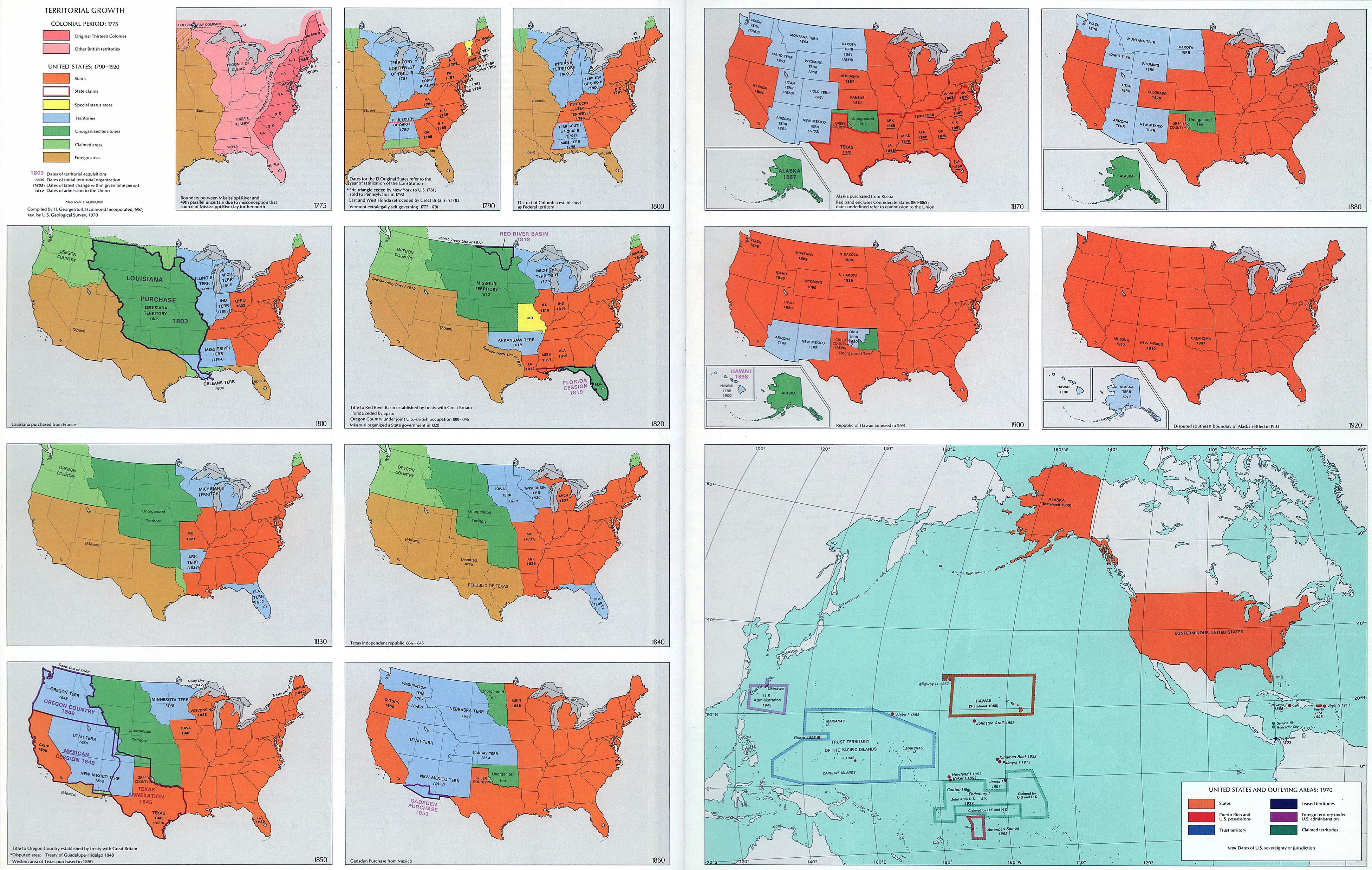
Fourteen history maps of the
United States: Territorial Growth 1775-1970
Illustrating:
Colonial Period: 1775
- Original Thirteen Colonies
- Other British territories
United States: 1790-1920
- States
- State claims
- Special status areas
- Territories
- Unorganized territories
- Claimed areas
- Foreign areas
Dates of territorial acquisitions
Dates of initial territorial organization
Dates of latest change within given time period
Dates of admission to the Union
Map I - 1775
Boundary between Mississippi River and 49th parallel uncertain due
to misconception that source of Mississippi
River lay further north. Proclamation Line of 1763.
Map II - 1790
Dates for the 13 Original States refer to the year of ratification
of the
 Constitution. Erie triangle
ceded by New York to U.S. 1781; sold to Pennsylvania in 1792. - East
and
 West Florida retroceded by
Great Britain in 1783. Vermont extralegally self governing
1777-1791.
Map III -
1800
District of Columbia established as Federal territory.
Map IV - 1810
Louisiana purchased from France.
 About the Louisiana Purchase, 1803
Map V - 1820
Title to Red River Basin established by treaty with Great Britain.
Florida ceded by Spain (
 Florida Cession
1819). Oregon Country under join U.S.-British occupation 1818-1846.
Spanish Treaty Line of 1819. Missouri
organized a State government in 1820.
Map VI - 1830
Oregon Country, Unorganized Territory, Michigan Territory, Arkansas
Territory, Florida Territory
Map VII -
1840
Texas independent republic 1836-1845
Map VIII -
1850
Title to Oregon Country established by treaty with Great Britain.
Texas Annexation 1845. Disputed area:
 Treaty of Guadalupe Hidalgo 1848.
Mexican Cession 1848. Western area of Texas purchased in 1850.
Map IX - 1860
 Gadsden Purchase 1854
from Mexico.
Map X - 1870
 Alaska purchased from Russia 1867. Red band encloses Confederate
States 1861-1865; dates underlined refer
to readmission to the Union.
Map XI - 1880
Washington Territory, Montana Territory, Idaho Territory, Wyoming
Territory, Dakota Territory, Utah Territory,
Colorado 1876, Arizona Territory, New Mexico Territory, Greer
County, Unorganized Territory, Alaska.
Map XII -
1900
Republic of Hawaii annexed in 1898. Oklahoma Territory.
Map XIII -
1920
Disputed southeast boundary of Alaska settled in 1903.
Map XIV -
1970
United States and Outlying Areas: 1970. States, Puerto Rico and U.S.
possessions, Trust territory, Leased
territories, Foreign territory under U.S. administration, Claimed
territories. Dates of U.S. sovereignty or jurisdiction.
Conterminous United States.
Credits
Compiled by H. George Stoll,
Hammond Incorporated, 1967; rev. by U.S. Geological Survey, 1970.
The University
of Texas at Austin. From the National Atlas of the United States of
America (1970).
Related Links
 About the American
Revolution
 About the Mexican-American War
 This map as PDF

More History
 |