|
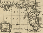
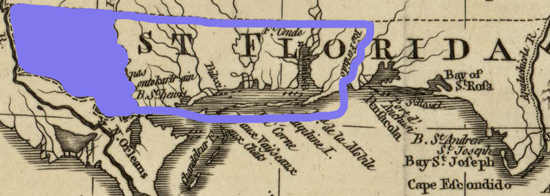
Map of West Florida
in 1763
Click to
enlarge
West Florida
The colonial province of West Florida existed from 1763
until 1821. Some argue it already ceased to exist in 1810, 1812, or 1819.
But technically and officially, the year is 1821.
|
|
Along with Quebec, East Florida,
and Grenada, West Florida was created with "distinct and separate
Governments" by King George III's
 Royal Proclamation of 1763.
West
Florida encompassed an area that is today part of the states
of Louisiana, Mississippi, Alabama, and Florida.
The boundaries of Britain's West
Florida, Spain's West Florida, and the Republic of West
Florida were not identical. |
As for you charming nitpickers, yes, it is true: At
some point the boundaries of Britain's West Florida and
Spain's West Florida were the same.
But never that of the Republic
of West Florida, no part of which, by the way, is located in
today's Florida. And still, the republic called itself State of
Florida.
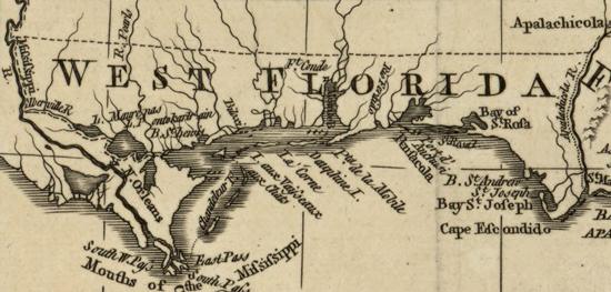
Image
Above
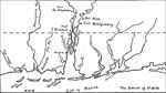
The map above shows
West Florida's original borders in 1763, which were:
- the 31st
parallel in the North,
- the Gulf of Mexico in the South,
- the
Apalachicola River in the East,
- and the
Mississippi River / Iberville River (Bayou
Manchac) in the
West, including Lake Maurepas and Lake Pontchartrain,
excluding New Orleans
West Florida's
Timeline in a Nutshell
|
1763
October 7 |
West Florida created
by the British |
| |
|
|
1763-1783 |
British Period |
| |
|
1783
September 3 |
Britain ceded West Florida to Spain
with the Treaty of Versailles |
| |
|
|
1783-1821 |
Spanish Period |
| |
|
1821
February 22 |
Spain
ceded West Florida to the U.S., who
divided it into bits, which were
henceforth called part of Louisiana,
Mississippi, Alabama, and Florida,
respectively |
Skip forward to 1763 when
West Florida was created,
or let's start from the top for a little bit of Floridian
background:
1513-1763
The first European on
record to visit Florida with consequences was Spanish
explorer and Columbus' former travel buddy
Juan Ponce de Leon, who
lived 1460-1521.
Setting sail from Puerto Rico, he arrived
on Florida's east coast in April 1513 somewhere between
today's St. Augustine and Melbourne Beach. Apparently it was
then and there that he named the land Florida.
Here's a French map of what
happened next:
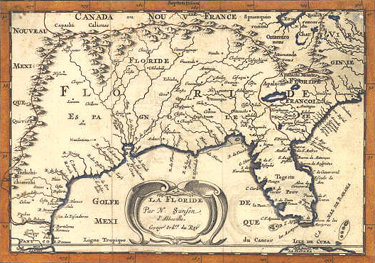
La Floride (La
Florida) 1657
Map by Nicolas Sanson of Abbeville, France, who lived 1600-1667
Florida Department of
State
And why did the French have a
contemporary map of Florida? Because they too were
enormously busy sticking their flags into North American
soil. So much so that it amounted to this:
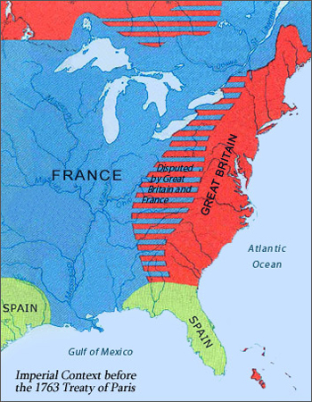
Map of North America Before the 1763 Treaty of Paris
Library of Congress
Let's zoom in on the future West Florida.
Here, the French and the Spanish met at the Perdido River:
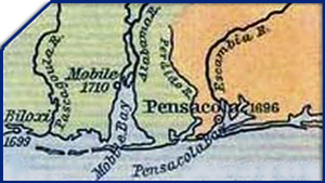
Map of the Southern Colonies, 1607-1760
Illustrating dates of
permanent settlements: Biloxi 1699 (French),
Mobile 1710 (French), Pensacola 1696 (Spanish)
(Fort Louis de la Mobile was built upriver from present-day
Mobile in 1702.)
Click to enlarge
But the Perdido River was a contested border between the two empires. For example,
Pensacola was in French hands from 1719 until 1722, after
which it was restored to Spain.
For this, the
War of the Quadruple Alliance
was partly to blame.
In 1754, the
French and Indian War
broke out. It would last until 1763 and would shuffle North American land ownership quite a bit.
On November 3, 1762, just before
the end of the war, the secret
Treaty of Fontainebleau
was signed. In it,
France ceded to Spain all of
Louisiana west of the Mississippi River, including New
Orleans.
1763-1775
The
Seven Years' War, and
with it its North American extension, the
French and Indian War,
ended with the
1763 Treaty of Paris,
signed
on February 10, 1763, to be exact.
Complying with this treaty, Britain gained Canada from the
French, and restored Cuba (which it had
been captured in August 1762) to Spain. Spain in turn ceded Florida to
Britain, ending the so-called First Spanish Period, and now the map looked as follows:
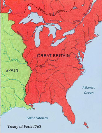
Map of North America After the 1763 Treaty of Paris
Treaty of Paris 1763
Please note: New Orleans
is incorrectly shown as British.
See more
here.
Library of Congress
Florida's exact western border was according to the
treaty:
... a line
drawn along the middle of the River
Mississippi, from its source to the river
Iberville, and from thence, by a line drawn
along the middle of this river, and the
lakes Maurepas and Pontchartrain to the sea;
...
...
except the
town of New Orleans and the island in which
it is situated, which shall remain to
France, provided that the navigation of the
river Mississippi shall be equally free, as
well to the subjects of Great Britain as to
those of France ...
Treaty of Paris 1763,
Transcript, The Avalon Project
Or, as illustrated on the map at the top of the page.
On August 5 and 6, 1763, the third battalion of the British
Royal American Regiment, led by
Lieutenant Colonel Augustin Prevost, arrived at
Pensacola. He met at once with former Spanish Governor
Don Diego Ortiz Parrilla,
who had orders to surrender immediately and to evacuate as
soon as possible.
This Spanish evacuation was on
its way one month later when 800 people left Pensacola for
Havana and Vera Cruz. Approx. 700 sturdy French residents in
and around Mobile stayed put.
Prevost didn't waste any time to
complain about the general mess he found himself surrounded by, which,
according to his own assessment, was unquestionably caused by the "insufferable laziness of
the Spaniards."
West Florida Created
By means of the
Royal Proclamation of 1763,
signed on October 7, 1763, the new owner
Britain divided Florida at the Apalachicola River into
East Florida and
West Florida, and drew
the northern border of West Florida at 31° latitude. Here
are the exact words from the proclamation:
Thirdly : The Government of West Florida, bounded to the Southward
by the Gulph of Mexico, including all Islands within Six Leagues* of
the Coast, from the River Apalachicola to Lake Pontchartrain; to the
Westward by the said Lake, the Lake Maurepas, and the River
Mississippi; to the Northward by a Line drawn due East from that
part of the River Mississippi which lies in 31 Degrees North
Latitude, to the River Apalachicola or Chatahouchee; and to the
Eastward by the said River.
*
1 marine
league = 3 nautical miles
And then: 1 nautical mile = 1.15 mile or
1.852 km
Therefore: 6 leagues = 18 nautical
miles = 20.714 miles or 33.336 km
And here's the entire map:
The Floridas - East and West Florida
1763
Click to enlarge
This
northern border was soon revised.
On
March 23, 1764, the bright people of the British Board of Trade, i.e. the gentlemen Hillsborough, Soame Jenyns, Ed. Elliott,
Geo. Rice, Orwell, Bam. Gascoyne, recommended
"to the King's
most excellent majesty"
to raise the northern boundary of
West Florida from currently at 31 degrees latitude to
"a
line drawn from the mouth of the river Yasous [Yazoo], where it
unites with the Mississippi, due east to the river
Apalachicola."
Why on earth?
Because
"it appears from
observations and surveys, made since the said province has
been in your majesty's possession, that there are not only
very considerable settlements upon the east bank of the
Mississippi above that line, but also that the town and
settlement of Mobile itself is some miles to the north of
it."
On June 6, 1764, the extension
of West Florida went into effect
"by other our letters
patent under our great seal of Great Britain, dated at
Westminster, the sixth day of June."
This was the West Florida Supplementary
Commission, June, 1764, to be found in W.L. Grant and James Munro
(editors), Acts of the Privy Council of England, Colonial
Series, 1613-1783 (6 volumes; London, 1908-12), this is
volume IV, page 668.
The Choctaw recognized this new
boundary with their treaty of March 26, 1765, agreed at
Mobile. The Creeks with their treaty of May 26, 1765, agreed
at Pensacola. Here is a map of the Indian tribes in the
area:
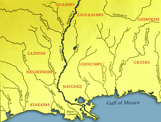
Map of the
Indian Tribes in the Mississippi Valley
Library of Congress
In other words, Britain extended their West Florida
territory to the north and added the area between the parallels at 31° and 32° 28' North.
(
Go here for more about Units
of Longitude and Latitude.)
This new northern border
remained in effect for the rest of the British occupation,
i.e. until 1783.
Here are the maps:
West Florida at Its Largest Extent: 1764-1783
Click to enlarge
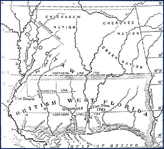
British
West Florida and Indian Nations
Illustrating: Chicksaw
Nation, Chicksaw Line, Choctaw,
Cherokee Nation, Creek Nation, Choctaw Line,
Northern Line of British West Florida in 1763 and in 1767
(actually 1764),
30 to 35 degrees latitude
Mississippi Historical Society
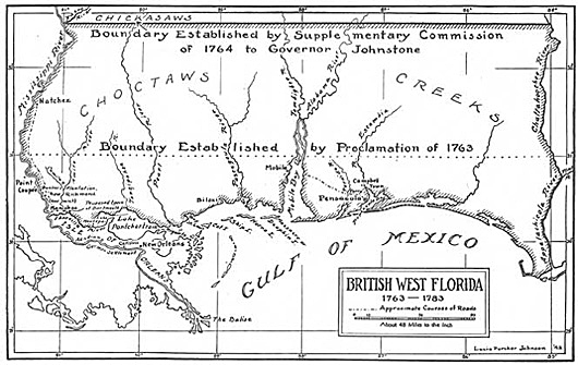
British West
Florida 1763-1783
Illustrating:
Chickasaws, Choctaws, Creeks,
Boundary Established by Proclamation of 1763,
Boundary Established by Supplementary Commission of 1764 to
Governor Johnstone
Lucia Porcher Johnson /
Mississippi Historical Society
:: What was the
real reason for this extension?
By his royal proclamation,
George III had made clear that the land in question was reserved for the Indians.
Settlements were prohibited. Here is the sound
bite:
And We do further
strictly enjoin and require all Persons whatever
who have either willfully or inadvertently
seated themselves upon any Lands within the
Countries above described or upon any other
Lands which, not having been ceded to or
purchased by Us, are still reserved to the said
Indians as aforesaid, forthwith to remove
themselves from such Settlements.
According to Clarence E. Carter
in Some Aspects of British Administration in West Florida, the reason
for violating the royal instructions was
simple, it was "land
fever."
In fact, the Lords of the Board
of Trade themselves were suffering from it badly. On June 5, 1764, one day before
the new border became official, they recommended several
land grants that were located north of the 31st parallel, thus beating everyone to the
punch.
:: 1764 or 1767 ?
Why do some maps and sources say
that this change of West Florida's northern border took
place in 1767 or even 1770 instead of 1764?
Back to Clarence E.
Carter's work, page 366, where he explains that,
This view is based in part upon an extract from the
commission of Governor Eliot (1767), published in American
State Papers; Public Lands, 1:57, in which the old boundary
of the thirty-first parallel is described. The complete
document describes the revised boundary.
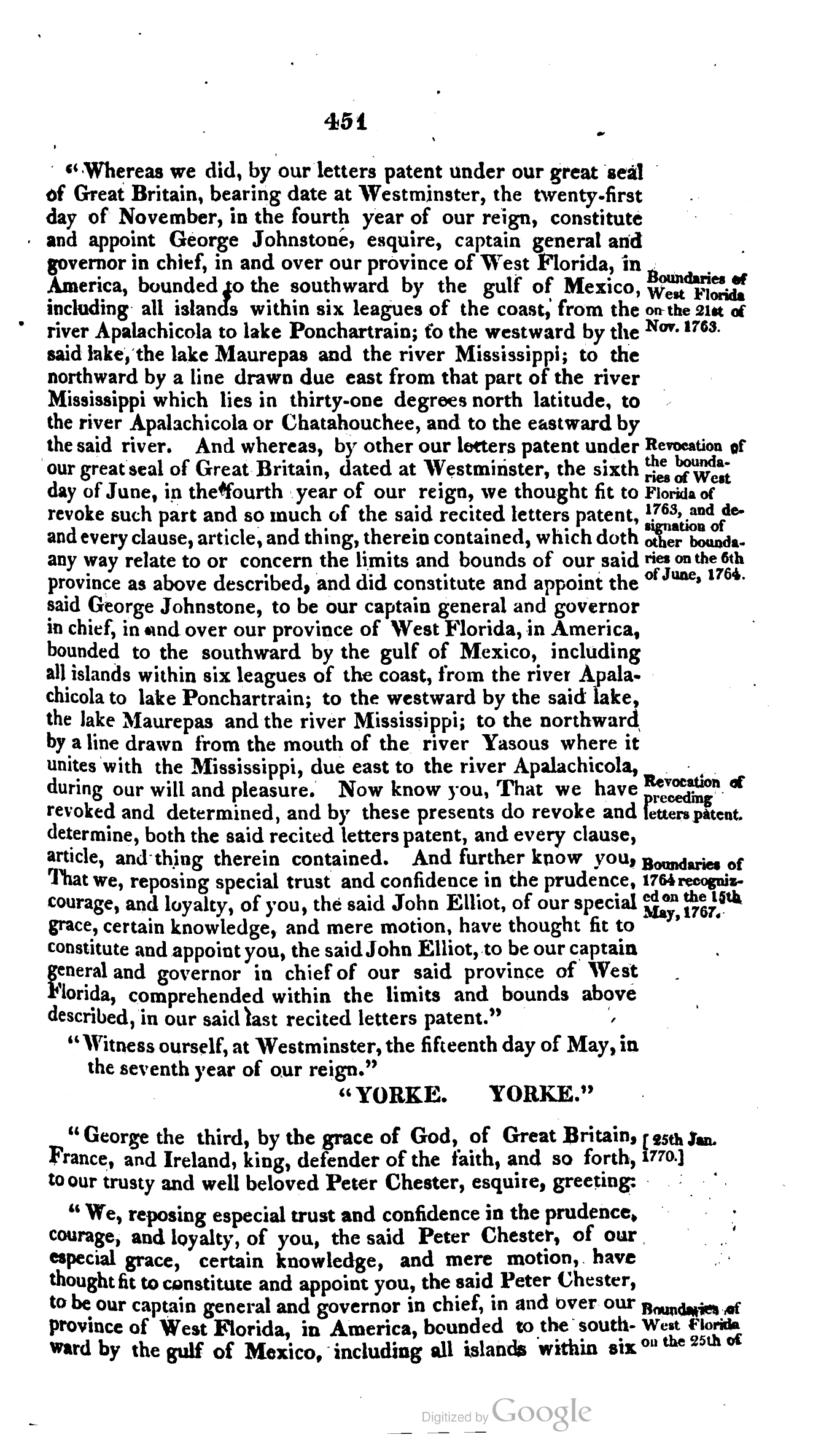
Once and for all, this will help
us out:
"Boundaries of West Florida on
the 25th of January, 1770, the same as on the 6th of June,
1764."
This is a margin annotation from
the Laws of the United States of
America ... and many other valuable ordinances and documents
with copious notes and references, Vol I of V; published
in 1815 by Bioren, Duane, and Weightman.
Here are pages page 449-452:
Now that we're clear on the
year of the border extension, back to the West Florida government.
On October 21, 1764, the first
civil governor of West Florida, George
Johnstone, arrived at Pensacola. The military
administration could retire.
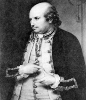
George
Johnstone, who lived 1730�1787
First Governor of British West
Florida
State Archives of
Florida, Florida Memory
But it still took until 1766 until
West Florida had an elected assembly.
Johnstone, by the way, was
recalled in 1767.
1775-1783
American Revolution
Apart from Canada, East and West Florida were the only provinces that
remained loyal to Britain during the
American Revolution
(1775-1783). Spain finally made its support for the Colonies
official when Spanish King
Charles III declared war on Britain on June
21, 1779.
Thus, West Florida saw action
in the later years of the American Revolution.
On August 27, 1779, Spanish troops led by 33-year-old governor
of Spanish Louisiana, Colonel Don Bernardo de Galvez,
departed from New Orleans.
On September 7, 1779, Galvez'
troops captured Fort Bute
(at the British village Manchac, not today's Manchac south
of Ponchatoula), where the British had left only a small
garrison because they judged the fort indefensible. Instead
they decided to retreat to Baton Rouge.
On September 21, 1779, the
Spanish overpowered the British, led by
Alexander Dickson, at
Baton Rouge. This was the Battle of
Fort New Richmond. Fort New Richmond, by the way,
was a makeshift fort, built with permission of the owners on
the grounds of the Watts and Flowers plantation on July 30,
1779. It was also called the Baton Rouge Redoubt.
At Baton Rouge, Galvez not only
demanded the surrender of Dickson's men there, but,
efficiently, also of
those at Fort Panmure at Natchez. On October 5, 1779,
Spain's Captain Juan Delavillebeuvre was on location and
accepted British Captain Anthony Forster's surrender without
incident.
On March 14, 1780, the Spanish defeated the British and captured Fort Charlotte (formerly
French Fort Conde) in today's downtown Mobile (Movila),
Alabama. This was the Battle of
Fort Charlotte, and it took place March 10-14,
1780. The Spanish renamed it Fort Carlotta.
Elias
Durnford, surveyor general, former interim
governor, and British commander of the fort
that surrendered to the Spanish, gave "the number by return of
killed, wounded, and prisoners, 304."
The British attempted to retake
the fort on January 7, 1781, but were defeated once again,
and the ones who didn't get killed retreated for a second time to Pensacola.
Then, on May 9, 1781, the
Spanish took West Florida's capital, Pensacola (Panzacola). See also
Siege of Pensacola.
British West Florida was now in Spanish hands.
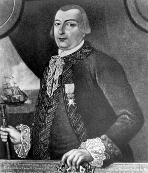
Spanish
Governor of Louisiana Bernardo de Galvez
Ousting the British
from West Florida,
thereby commencing the so-called Second Spanish Period
State Archives of Florida,
Florida Memory
These Spanish victories were
achieved under Bernardo de Galvez,
whom, for assisting in the fight against the British, the Americans
made posthumously an honorary U.S. citizen in December 2014.
1783-1795
Concluding the
American Revolution
with the
1783 Peace of Paris,
Britain returned the Floridas to Spain, who kept the
division between La Florida Occidental (West Florida) and La
Florida Oriental (East Florida). To be exact, this was the
Treaty of Versailles.
Spain figured that West Florida's northern border was the way it
had been since 1764. The U.S. begged to differ and claimed the
land all the way down to 31°
latitude. This marked the beginning of the
West Florida Controversy.
This dispute remained unresolved until
1795.
West Florida Underneath Disputed Area
in Green: 1783-1795
Click to enlarge
1795-1810
Settling the dispute
over the northern part of West Florida, on October 27, 1795,
the U.S. and Spain signed the
Treaty of San Lorenzo, also called
Pinckney's Treaty, named
after the American diplomat Thomas Pinckney who brokered and
signed the
deal. Via this treaty Spain agreed to relinquish the
disputed area, which included the Natchez District.
However, the Spanish were in no hurry to evacuate. This, in
combination with poor American diplomatic conduct, resulted
in two more years of Spanish activity in the region.
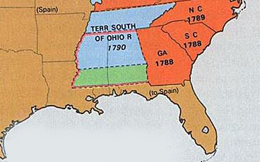
In March 1798, the Spanish finally
decided to pack their bags. On April 7, 1798, the U.S. shut
the door behind them and created the
Mississippi Territory,
which looked as follows:
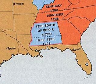
West Florida Underneath Mississippi
Territory: 1798-1810
Click to enlarge
This also meant that West
Florida had once again its map shape from 1763 to 1764.
Here is another map for the year
1802, looking a little itchy, but it shows the 31st to the 35th parallel on the left (barely, but
still):
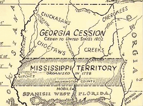
Map of the
1802 Georgia Cession
Illustrating the
Mississippi Territory, organized in 1798,
Spanish West Florida, and the
Spanish-U.S. Border at 31st parallel
Nathan H. Glick pen and ink drawings /
Alabama Department of Archives and History
In the meantime, Napoleon had Spain convinced to retrocede
Louisiana to France. This was the
Treaty of San Ildefonso
(October 1, 1800) and the
Convention of Aranjuez (March 21, 1801).
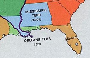
In 1803, the U.S. obtained the Louisiana Territory from the French
(see
Louisiana Purchase.)
1810
In the
West Florida Revolt of 1810,
part of Spanish West Florida rose up and declared themselves
the independent
Republic of West Florida. The
magic lasted for 74
days, from September 26 to December 8, 1810.
The Republic of West Florida
reached from the Mississippi to the Pearl River (River of
Pearls). Here is the
map:
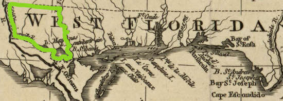
Border Line of
the Republic of West Florida 1810
Click to
enlarge
Here is a map of the area enlarged:
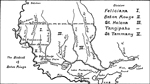
West Florida 1810: The
District of Baton Rouge
Click to enlarge
And this is the same area on a different map:
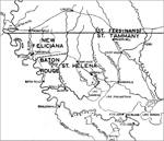
Western West Florida 1810
Click to enlarge
On October 27, 1810, U.S. President Madison issued a
declaration proclaiming West Florida from the Mississippi,
not only to the Pearl River, but all the way to
the Perdido River, U.S. territory.
And just in case you were
wondering, West
Florida's absorption by the United States will be
completed in 1819, and all the papers will be in order by
1821.
On December 8, 1810, U.S.
troops, led by the governor of Orleans Territory
William C.C. Claiborne,
arrived at the Republic's capital, St. Francisville, located just above Baton Rouge.
President Madison's proclamation was read to the public, the
Republic's flag was ordered to be lowered, and the U.S. flag
was hoisted in
its stead. Done. Annexed.
Spain looked on but did not have
the muscle to interfere, a fact that Madison had well
pondered.
Why was Spain weak?
Napoleon.
See more under
Background of the West Florida Revolt.
So, by the end of the year 1810,
the U.S. had occupied the region of the former Republic of
West Florida, and additionally claimed the area all the way to the Perdido River:
U.S. Claims in
West Florida: End of 1810
Click to
enlarge
In other words:
More Than Half of West Florida Claimed
by the U.S.: December 1810
Claimed, in green, but not yet
all of it occupied.
Also illustrated here is the 1804 extension of the
Mississippi Territory.
Its northern border was raised to the Tennessee state line.
Click to enlarge
1811
The following text is
from November 20, 1811, legislation from the 12th Congress,
1st session, Number 296:
A petition by the inhabitants of West
Florida asking for the annexation of West Florida to the
Mississippi Territory
The petition is signed "George
Patterson and 410 others" who were afraid that the U.S.
would "either continue us a separate territory, or attach us
to the Territory of New Orleans, instead of incorporating us
with the Mississippi Territory."
The link will take you to the
State Library of Louisiana.
1812
On April 8, 1812,
Congress declared Louisiana (Orleans Territory) one of
the United States of America, effective April 30, 1812.
On April 14, 1812, Congress added to the state of Louisiana
the Florida Parishes,
which is the land between the Mississippi and Pearl River,
the area that had been briefly a republic in 1810.
On May 14, 1812, the middle part of West Florida, from the
Pearl River to the Perdido River, was added to the Territory
of Mississippi.
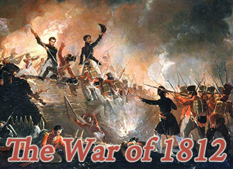
On June 18, 1812, U.S. President James Madison signed the declaration of war
against Great Britain. The
War of 1812 had begun.
It would last until February 1815.
1813
On
April 12, 1813, U.S.
forces, led by James Wilkinson, seized Mobile. The Spanish evacuated the town on April
15, 1813.
And thus, the green bit of West
Florida on the above map was now not only claimed but also
occupied by the U.S.
1814-1815
The
War of 1812 (United
States vs. Great Britain) raged on and reached West Florida.
On September 14 and 15, 1814,
the British
attempted to take Fort Bowyer
on the Mobile Point peninsula, overlooking Mobile Bay, but
the fort was able to defend itself.
On November 7, 1814, U.S. Major
General
Andrew Jackson
and his men invaded Pensacola, and then retreated to Mobile
where he waited for the British attack. When
it didn't materialize, Jackson rightly concluded that Britain's
next target was not Mobile, but New Orleans.
The
Battle of New Orleans
was fought on January 8, 1815.
Mobile, however, was still on
the British wish list. On February 11, 1815, and this time
with overwhelming force, the
British took Fort Bowyer.
This was the last battle of the
War of
1812, before it ended on February 17,
1815.
It seemed that
Spain, preoccupied and enfeebled by the
Napoleonic Wars
(1803-1815), just looked on as foreign
troops came and went as it pleased them.
1816-1818
On November 30, 1817, the
Apalachicola Massacre,
also called the Scott Massacre,
triggered the First Seminole War,
which in turn triggered Andrew Jackson's raid against
escaped slaves, the Seminoles, and the Spanish alike.
In May 1818, Jackson took
Pensacola again, this time for good.
Colonel
William King was the civil and military governor of
the Province of West Florida from May 26, 1818 until
February 4, 1819.
1819 - Today
On February 22, 1819,
and after lengthy negotiations, the
Transcontinental Treaty
was signed.
Who signed?
John Quincy Adams for the U.S.
and Luis De Onis for Spain.
By means of this treaty, Spain
ceded East and West Florida to the U.S. and gained Texas.
The
agreement is also called the Adams-Onis Treaty or the
Purchase of
Florida.
Therefore:
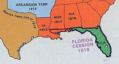
The Floridas Entirely in American
Hands: 1819
Spain gets Texas to California.
Click to enlarge
The exchange of ratifications of the 1819 treaty
was completed on February 22, 1821.
On March 10, 1821, President
Monroe made Major General Andrew Jackson Commissioner of the
United States and invested Jackson with "full powers."
On July 10, 1821, at St.
Augustine, East Florida, Robert
Butler formally received the province from José Coppinger,
the last
Spanish governor of East Florida.
On July 17, 1821, the formal
exchange of flags took place at Pensacola between the last
Spanish governor of West Florida, Jose Callava, and Andrew
Jackson.
Jackson delivered a brief
speech, here is an excerpt:
I have, therefore, thought fit
to issue this my proclamation, making known the premises,
and to declare that the government heretofore exercised over
the said provinces, under the authority of Spain, has
ceased, and that that of the United States of America is
established over the same; that the inhabitants thereof will
be incorporated in the Union of the United States as soon as
may be consistent with the principles of the Federal
Constitution, and admitted to the enjoyment of all the
privileges, rights, and immunities of the citizens of the
United States [etc.]
And an almost melancholy Thomas Corwin
Donaldson comments
And thus the
banner of Spain, which was first raised in
Florida April 8, 1512, giving place
temporarily to the English from 1736 to
1783, was on the 10th and 17th of July,
1821, after a period of about three hundred
and eight years, replaced by the flag of the
United States.
The Public
Domain - Its History, with Statistics, page
119
Pensacola's fine citizens
commemorated this event by placing a bust of Jackson in
their Plaza Ferdinand VII, with an inscription that reads:
In this plaza General Andrew Jackson received West Florida
from Spain and raised the flag of the U.S. July 17, 1821
Back to 1821.
Jackson resigned his post, and
William Pope Duval, a United States judge, became governor
of the Territory of Florida in 1822.
Florida was a U.S. Territory until 1845.
On March 3, 1845, Florida became
the 27th state to join the Union.
So far the timeline.
What Was the Capital
of West Florida?
The capital of both, British and
Spanish West Florida was
Pensacola.
St. Augustine was the capital of both,
British and Spanish East Florida.
What Was the Capital
of the Republic of West Florida?
The capital of the Republic of West
Florida was St. Francisville, located 30 miles north of Baton Rouge
in today's Louisiana.
The Republic of West Florida existed
from September 23 to December 10, 1810. St. Francisville was a
capital for 74 days.

You can actually click this thing
How Many People Lived
in West Florida?
Right before the Spanish evacuated in
1763, Pensacola had a population of less than 800 people. This
number included the Spanish soldiers and officials, their families
and staff, and more than a hundred convicts. Regular civilians (men,
women, children) totaled only slightly more than a hundred.
Thus, when the British took over in
1763, they inherited the small village of Pensacola with approx. 100
hut like dwellings encircled by a stockade.
The same year, approx. 28,000 Native Americans far
outnumbered European settlers. Consequently, British West Florida's
main challenges were to keep peace with the Natives and to attract
settlers. In fact, right after his arrival, West Florida's first
governor George Johnstone sent Lieutenant
Alexander Maclellan to New Orleans to encourage residents of
southern Louisiana to move to West Florida. The result of this campaign was not
overwhelming.
A big problem were forsaken lots
belonging to "absentee landlords", i.e. rich Europeans who bought
land only to speculate, without any intention to settle or
cultivate it.
In 1766, Governor Johnstone estimated
the total colonial population of West Florida to be about 1,800 to 2,000.
In 1768, Pensacola had 200 houses, which were arranged according to
the lots in surveyor Elias Durnford's
new town plan. These lots were 80 by 160 feet plus attached garden
lot, and they had been allocated free of charge.
But you had to build a brick chimney within two years and pay 6 English pence per annum.
In 1774, the same Elias Durnford estimated the population between
the Mississippi and the Iberville and Yazoo Rivers at 2,500 white
and 600 black.
In 1785, there were approx. 3,660
European settlers in West Florida.
By 1795, this number had grown to approx. 8,390
European settlers in West Florida.
But by 1798, it got reduced again by
approx. 50
% because of the territory loss negotiated in
Treaty of San Lorenzo.
What Indian Nations Lived
in West Florida?
The Chickasaw, the Choctaw, and the Creek
(Seminole.)
What is the
West Florida
Controversy?
A land dispute between the United
States and Spain.
The West Florida Controversy can be
divided into two chapters:
1783-1795:
Dispute over the area
between the parallels 31° and 32° 28' North, solved on October
27, 1795, by the Treaty of San Lorenzo.
1810-1819:
Dispute over the area from
the Gulf of Mexico to the 31st parallel, from the Mississippi River
to the Perdido River, claimed by the U.S. in October 1810, who backdated their claim to 1803 (see
Louisiana
Purchase).
The West Florida Controversy ended in
1821 with the ratification of the
Adams-Onis
Treaty, also called the Transcontinental Treaty.
The History of West Florida in a Nutshell
Handy all in one map:
Acquisition of West Florida 1767-1819
Click to enlarge
More Maps
West Florida 1810: District of Mobile
Click to enlarge
More West Florida
Go here for a
complete list of all British and Spanish
governors of West Florida as well as main events during their
governorship.
A Nerd's Delight
Go here for the
Florida Statues, Volume III, an
archived PDF file from 1941, published by the State of Florida.
Process Verbal at Pensacola on July 17, 1821, is on page 111. Thank
me later.*
* = That's page 111 on the scanned doc, but page 112 of the PDF.
Or, should this link forsake you,
heaven forbid, kick back with the
Acts of the Legislative council of the
Territory of Florida together with the Treaty of
Cession, Governor Jackson's Ordinances, the Act of Congress
organizing the Territorial Government, Constitutions of the United
States, Spanish regulations for the allotment of lands etc., kindly
provided by the George A. Smathers Libraries, University of Florida.
You will find Pensacola's
process verbal on page XII.
More History
|