|

MAP LOCATION
OF KALMAR, SWEDEN
Kalmar Union 1397-1523
|
|
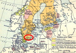
Map above:
Illustrating the
location of Kalmar, Sweden.
Click map to
enlarge. |
The Kalmar Union united Denmark, Norway, and Sweden under one ruler.
Sweden dropped out of the Union and became independent in 1523.
About Kalmar
Kalmar is a city and a county
on the Swedish east coast. Above is the map. On it, you will find Kalmar spelled Calmar.
What Happened at
Kalmar?
 Margaret I was the Queen of Denmark, Norway, and
Sweden. But separately. She became queen of Denmark in 1375,
of Norway in 1380 and of Sweden in 1389.
Margaret thought one might as well merge Scandinavia.
Therefore she assembled
all responsible individuals at Kalmar and, on June 17, 1397, they
crowned her sister's grandson, which also was Margaret's adopted son, Erik.
Thus, Erik of Pomerania became
Erik VII, king of the united dominions of Denmark, Norway, and
Sweden. On paper, that is. Margaret was glued to her chair and kept ruling until her
death.
The End of the Kalmar
Union
Sweden
broke away from the Union in 1523 under their new king
 Gustav I Vasa.
Norway tried
something similar and started a civil war with Denmark. The action
backfired, the Danes put their foot down and declared Norway a
Danish province in 1536.
See also
 Christian II.
More History
|